Lower Kabete, Nairobi info@geotechsysafrica.org
Navigating the Digital Terrain

Web Development

Nakuru City Sustainable Development Platform

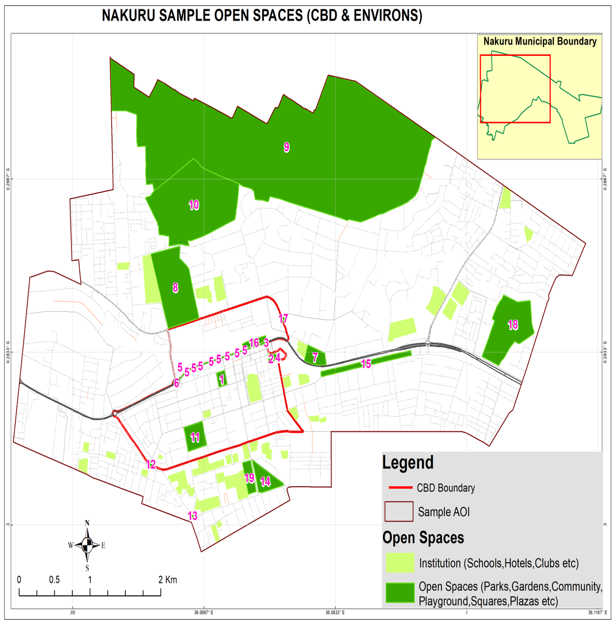
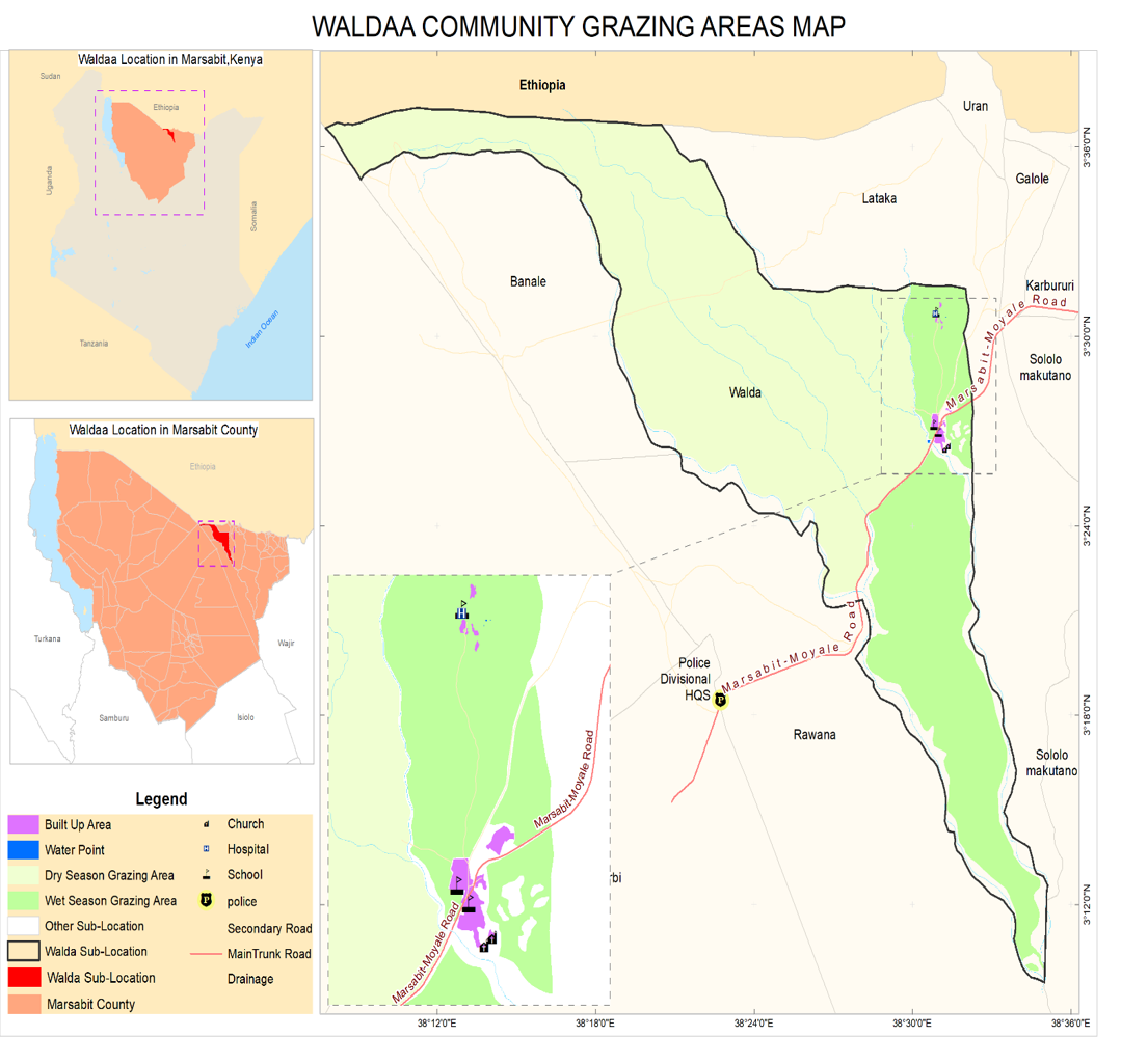
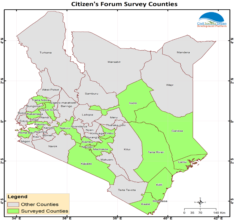
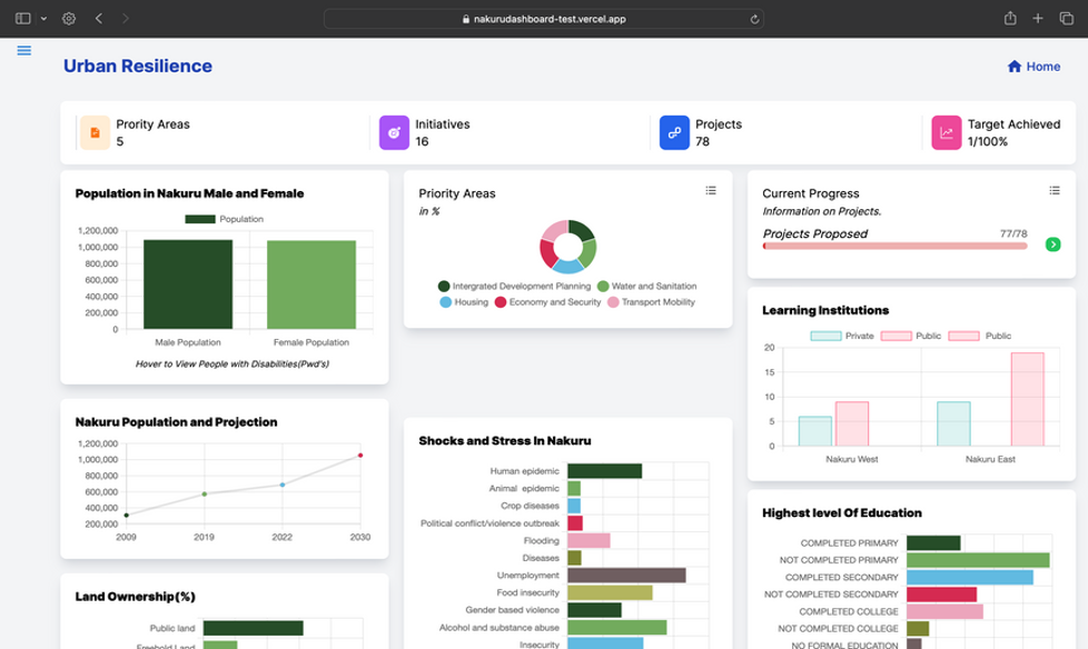
As a member of the Just City Working Group (JSWG), we played a pivotal role in the development of the Nakuru City Development Priorities Visualization System. Tasked with supporting the JSWG project, we were instrumental in visualizing Nakuru Urban Resilience Data. This initiative aimed to empower the Nakuru City board with data-driven decision-making capabilities and the ability to monitor the progress of urban resilience projects nationwide.

More Details

Research, Survey

Women and the Blue Economy Baseline

In partnership with Malaika Foundation, we are currently conducting the Women and Blue Economy Baseline Project Survey. The scope of this research project revolves around understanding the dynamics of the blue economy and its impact on the productivity of the female population. Specifically, our focus is on conducting a thorough examination of the socioeconomic aspects of Masese Beach in Jinja, Uganda, and Dunga Beach in Kisumu City, Kenya, both located on Lake Victoria.

More Details

Research, Survey

Kisumu Turning Waste to Jobs Project-Households Baseline

The Kisumu Turning Waste to Jobs Project - Households Baseline, conducted in collaboration with unhabitat, csudp and Kisumu City, aimed to advance community-based solid waste management and establish a facilitating framework for a Public Private People Partnership (PPPP) in the low-income areas and informal settlements of Kisumu City, Kenya.

More Details

Research, Survey

Taita Taveta Go Blue Project-Waste Recycling Actors Survey

The Taita Taveta Go Blue Project - Waste Recycling Actors Survey, in collaboration with Unhabitat, csudp, and Mombasa County, aimed to enhance municipal solid waste management systems in Taita Taveta County. Geotechsys Africa played a crucial role in data collection, analysis, reporting, and GIS mapping to support the county government's efforts to upgrade its waste recovery facility at Chakaleri. The project also focused on involving women and young people in waste recycling and management to create employment opportunities and promote environmental sustainability.

More Details

GIS Mapping, Survey

GIS Mapping of Nakuru Urban Spaces to Inform Urban Dialogue

Geotechsys Africa Ltd, in collaboration with the Nakuru City Board, conducted a comprehensive GIS mapping exercise of open spaces within the city of Nakuru.

More Details

GIS Mapping, Survey

Map Tenure Presentation of Waldaa Community and Key Rangelands Resources Marsabit County

In collaboration with www.reconcile-ea.org and www.ilri.org, Geotechsys Africa engaged in the Map Tenure Presentation of Waldaa Community and Key Rangelands Resources in Marsabit County. Through the use of Participatory Geographic Information Systems (PGIS), our goal was to generate spatial knowledge about pastoralist land tenures and livestock corridors in the Waldaa Community, located in Moyale and Marsabit, Kenya.

More Details

GIS Mapping, Survey

Citizens Forum Handbook for Cities/Municipalities in Kenya

The Ministry of Lands, Public Works, Housing, and Urban Development, along with key partners, initiated a comprehensive survey under the Kenya Urban Support Program (KUSP) to assess urban governance and management practices across Kenya. Our role encompassed providing an online data collection tool, monitoring data collection, analysis, mapping, and reporting

More Details

GIS Mapping, Survey

Community Co-Design Participatory Planning Project – UCODE

Geotechsys Africa, collaborating with partners www.kenya.fes.de, www.csudp.org, and www.tu-dresden.de, completed the Community Co-Design Participatory Planning Project (UCODE).

More Details

GIS Mapping, Survey

Co-Design Participatory Processes and Preparation of Detailed Public Space Design Proposals.

We collaborated with the Public Space Network NGO on projects promoting safe, inclusive public spaces in Nairobi. Our role involved providing technical support to student trainees.

More Details